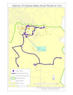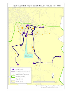

This week we looked at the same three wine sales territories in Napa County and used Network Analyst to find the best route - NA can do this by time, using a field for speed limit for each road segment, or by miles, which is how we did it - for a sales representative in each territory, starting from the sales rep's home. For this particular exercise we selected the top 10 sales in each territory, created a list of sales stops from these 10 (using Network Analyst), and then created a route, again using Network Analyst, that takes the sales rep from the home starting point to all the 10 stops.
Interestingly, the default route is based on the number of the OBJECTID field in the sales prospects attribute table, rather than any other geographically-related field, so this route is likely to be a) long and b) nonsensical: for an entertaining example of this, see the map on the right (the Non-Optimal one for the South territory). If you look closely at the numbers to see the order of stops, you can see how little sense it makes.
Interestingly, the default route is based on the number of the OBJECTID field in the sales prospects attribute table, rather than any other geographically-related field, so this route is likely to be a) long and b) nonsensical: for an entertaining example of this, see the map on the right (the Non-Optimal one for the South territory). If you look closely at the numbers to see the order of stops, you can see how little sense it makes.
As I mentioned above, however, Network Analyst does have a setting that allows you to create an "optimal" route, in this example the one with the smallest number of miles to cover: see the map on the left. It also allows you to print out a set of directions from to get you from designated stop to designated stop. You will note though that many stops near the 10-highest-sales ones are not included in this example. Left unaddressed is who is going to trail along and pick up the slack using another, less lucrative route!
We could have symbolized the roads in these maps according to the prevailing format - freeways in 3.4 width red, lesser highways in black with the usual symbol, etc. - but the important thing in this map is really the route the sales rep is supposed to follow. Hence I chose to leave the non-route routes in pale grey regardless of their size, and the route roads are the only ones I labeled since they are the ones that the sales rep is looking for. If I were the sales rep I would also throw a good, large-scale county map into the car/truck, just as insurance: ArcGIS directions are only as good as the data, and we know that Google directions, which are generally pretty good and which probably come from very similar data, can slip up royally from time to time.
Related to this is the fact that one of the sales stops on the original map for the Northeast territory could not be located by Network Analyst. It appears that the road on which it sits does exist, but it wasn't in the road network dataset that we used. So the stop was located correctly, but Network Analyst couldn't figure out how to get there because it couldn't see the road. I tried to move the sales stop point to the nearest road, but ran into immediate difficulties as when I reran the route calculations, nearly half of the sales spots showed up as not located. So I took the easy route, so to speak, and dropped the problematic sales stop in favor of the one next on the sales list. If I had a bit more familiarity with NA I expect I could have fixed this, but Project 5 is looming and it's Tuesday already.
No comments:
Post a Comment