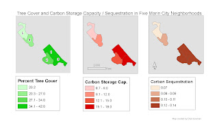
This week we had to calculate tree cover from our previous week's raster creation. Last week we had to generalize a raster that was classified into 50 classes (or 25 if ArcMap kept crashing), and generalize it to 3 classes: trees, grass and impervious surfaces. (So that's how it's done!) This week we calculated the area of the tree cover as a percent of the whole, and also did some carbon sequestration calculations. The three resulting maps (shown here) are quite similar. The 2nd and 3rd display, carbon storage and carbon sequestration, are really the same thing multiplied by a different constant.
This week I learned more (than I wanted to know, really) about the Field Calculator, but it was useful. I also discovered how to join the five neighbhorhoods that we focused on, using the Append function. That was useful too.
Last week we had the task of joining 7 smaller rasters into one big file. This didn't go at all well for me until Mari suggested using mosaicking, a technique I had never used before but that was very useful and worked like a charm.
All in all things are going pretty well. Except for the eyestrain this week...
No comments:
Post a Comment